Learning Objectives

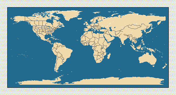
2. Label the following land masses:
3. Draw in the major rivers and tributaries found near your home. Be sure to include how they lead to the ocean.
4. The following locations are used as examples in the exhibition. Some represent land locations that have a tie to the oceans and others represent actual ocean "seamarks." Plot and label the following latitude and longitude coordinates or oceanic features:
  a.           24N                   75W     Bahamas

  b.            8S                  115E     Bali

  c.           58N                  160W     Bering Sea

  d.           38N                   77W     Chesapeake Bay

  e.           68N                   25W     Denmark Strait

  f.           45N                   83W     Great Lakes

  g.                                         Gulf Stream

  h.           37N                  108W     Ignacio Colorado

  i.            2S                   41E     Lamu Kenya

  j.           10N                  177E     Marshall Island

  k.           43N                   70W     Maine

  l.           11N                  142E     Mariana Trench

  m.           19N                  155W     Mauna Kea

  n.                                         Mid Ocean Ridge

  o.           53N                   56W     Newfoundland

  p.           41N                   73W     NY/New Jersey Beaches

  q.           48N                  161W     Nike shoes

  r.           12S                   77W     Peru

  s.           63N                   14E     Scandinavia

  t.            8S                  160E     Solomon Island
        Map              - Ocean Planet Link

a.      Bahamas          - dive site for the Johnson Sea Link
b.      Bali             - temple for fisherman's safe return
c.      Bering Sea       - king crab fishing
d.      Chesapeake Bay   - nursery grounds for the Atlantic Ocean
e.      Denmark Strait   - underwater marine waterfall
f.      Great Lakes      - colonized by zebra mussels
g.      Gulf Stream      - warm current off the eastern coast of the U.S.
h.      Ignacio Colorado - Margit Hentschel organized an oil recycling program
i.      Lamu, Kenya      - fishing charm
j.      Marshall Island  - navigation stick chart
k.      Maine            - lobster fishing
l.      Mariana Trench   - deepest point in the ocean at 6.8 miles
m.      Mauna Kea        - highest mountain on earth rises 33,465 feet from the sea floor
n.      Mid-Ocean Ridge  - longest mountain chain, stretching 46,000 miles
o.      Newfoundland     - cod declines
p.      N.Y/N.J Beaches  - medical wastes
q.      Nike shoes       - spilled from a cargo ship May 1990
r.      Peru             - El Nino
s.      Scandinavia      - cod liver oil
t.      Solomon Island   - shark priest's fishing boat
![]() Ocean Planet Exhibition Floorplan
Ocean Planet Exhibition Floorplan
![]()